The critical conditions found on the mining face
CCM Engenharia was asked to assess a mining face with very high, nearly vertical overall slopes. The inspection identified scars consistent with planar failures, detached blocks and a sector where the slope had collapsed completely.
The operation did not have a structured mine plan or a previous geotechnical study capable of guiding pit geometry. The challenge was therefore not simply to correct one isolated point, but to restore technical control over the mine's development.
Why LiDAR mapping was the starting point
LiDAR made it possible to record the pit faces in three dimensions and create a continuous geometric basis for the diagnosis. On high or hard-to-access slopes, the point cloud reduces dependence on isolated observations and helps measure the orientation, extent and spatial relationship of visible features.
This representation does not replace field geology. It improves the context in which observations are interpreted. Value appears when survey geometry is combined with structural data, evidence of failure and planning objectives.
Scanlines and discontinuity characterization
The team conducted field scanlines to characterize discontinuities and identify the most critical sets. This type of survey records the orientation and recurrence of structures that control rock-mass behavior.
The statistical analysis then sought to identify where sliding planes and release surfaces could combine unfavorably. The objective was not to classify every fracture in isolation, but to understand which mechanisms could control the stability of slope sectors.
- Integrated interpretation of face geometry and geological structures
- Identification of the most relevant discontinuity sets
- Assessment of combinations capable of forming failure mechanisms
- Separation of sectors requiring different geometric criteria
From diagnosis to slope redesign
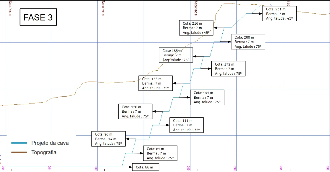
With the geometry and structural model consolidated, CCMENG reviewed benches, face angles and overall slope angles. The redesign sought to align the pit with the observed geomechanical behavior rather than preserve a uniform geometry that ignored differences among sectors.
Reshaping does not simply mean reducing every angle. An overly conservative solution may sterilize material and increase movement, while an aggressive solution may transfer risk to people, equipment and operational continuity. The design must balance safety, access, mining and resource recovery through verifiable assumptions.
The expected result goes beyond stability
The result of this type of study is the restoration of conditions for operating under clear criteria. Slopes that reflect the reality of the rock mass help protect teams at the mining face, reduce unplanned shutdowns and guide mine advance.
Updates must continue after the intervention. New exposures may reveal structures that were previously inaccessible, and observed performance should feed back into the model. Mine geotechnics is an ongoing monitoring process, not a permanent snapshot.
Signs that a pit needs geotechnical review
Some signs justify stopping the repetition of the existing design and reassessing the criteria. The sooner they are documented, the greater the opportunity for planned action.
- Scars, loose blocks or recurring rockfalls
- Slopes built with geometry different from the design
- Lack of geotechnical zoning and domain-specific criteria
- Pit expansion without updated structural data
- Frequent shutdowns for emergency corrections
Integration between geotechnics and mine planning
CCMENG integrates geology, geotechnics and geomechanics with mine planning so that geometric design, sequencing and field controls use the same technical basis.
Mining without geotechnics turns uncertainty into exposure. When surveying, interpretation and design work together, the operation understands its limits better and can make earlier decisions.
Explore CCMENG's geology, geotechnics and geomechanics services↗
Frequently asked questions
Questions about this topic
What is open-pit slope redesign?
It is the design and execution of new slope geometry, including benches, face angles and overall angles, according to the mine's geological, geotechnical and operating conditions.
How does LiDAR support slope stability?
LiDAR records faces in three dimensions and provides a dense basis for measuring geometry, locating features and integrating structural observations into the geotechnical model.
Does LiDAR replace field geological mapping?
No. The point cloud expands geometric coverage, but discontinuity characterization, mechanism interpretation and assumption validation still require geological and geotechnical fieldwork.
Need this expertise in your project?
Talk to CCMENG to assess your data, objectives and the most appropriate engineering approach.
Talk to a specialist↗